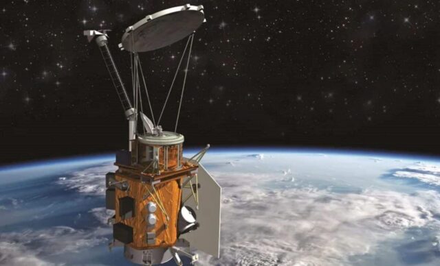
The U.S. Space Force has awarded SpaceX an $81.6 million contract to launch the Weather System Follow-on – Microwave Space Vehicle 2 (WSF-M2) satellite. This mission, designated USSF-178, is slated for 2027 and represents a continuation of SpaceX’s growing involvement in national security space operations. The contract, part of the National Security Space Launch (NSSL) Phase 3 program, underscores the U.S. government’s reliance on commercial space providers for essential missions.
Key Takeaways:
- SpaceX received an $81.6 million contract from the U.S. Space Force.
- The contract is for the launch of the Weather System Follow-on – Microwave Space Vehicle 2 (WSF-M2) satellite.
- The launch, designated USSF-178, is scheduled for 2027.
- WSF-M2 is the second and final satellite in the WSF-M series, providing vital weather data for military and civilian operations.
- This contract marks SpaceX’s third consecutive win under the National Security Space Launch (NSSL) Phase 3 program.
- The satellite will supply data on tropical cyclone intensity, storm tracking, space weather, sea ice, soil moisture, and snow depth.
- The Falcon rocket family, known for its reliability and cost-effectiveness, will likely be used for this mission.
A Crucial Asset for National Security and Beyond
The WSF-M2 satellite is designed to provide critical environmental intelligence for the U.S. military. This data is not solely for tactical operations; it has broad implications for disaster preparedness, climate monitoring, and civilian activities. The satellite’s instruments will measure ocean surface vector winds, information vital for assessing tropical storm intensity and their development. Beyond tropical cyclones, WSF-M2 will monitor space weather, tracking energetic charged particles that can affect satellite operations and communications. This extends to protecting vital infrastructure, from GPS systems to power grids, which are susceptible to geomagnetic storms.
The significance of the Weather System Follow-on – Microwave (WSF-M) program cannot be overstated. The first satellite in the series, WSF-M1, launched in April 2024. With WSF-M2 joining its counterpart in sun-synchronous orbit, the constellation will offer continuous global coverage. This orbit allows the satellites to pass over the same spot on Earth at the same local time each day, enabling consistent, repeatable measurements across the globe.
Colonel Matthew Flahive, chief of Launch Mission Solutions Delta at the Space Systems Command, highlighted the strategic advantage of flexible satellite manifestation. “It is a strategic advantage when we can flexibly manifest small satellites on our launch vehicles with additional capacity to support emergent operational requirements and the research and development community,” he stated. This reflects a shift towards leveraging adaptable launch capabilities, a characteristic that SpaceX consistently offers with its Falcon rockets.
SpaceX’s Expanding Role in Government Launches
This $81.6 million award is the latest in a series of contracts that show SpaceX’s growing position in U.S. national security space missions. The company has secured three consecutive wins under the NSSL Phase 3 initiative, demonstrating its operational reliability and capability in handling complex, high-stakes military satellite launches. This trend signals a broader acknowledgment of commercial space sector capabilities to support government needs.
SpaceX, founded by Elon Musk in 2002, has quickly grown to become a dominant force in the space industry. Its Falcon 9 rocket, known for its reusability, has significantly reduced launch costs and increased launch frequency. The Falcon 9 stands at 70 meters (229.6 feet) tall with a diameter of 3.7 meters (12 feet) and a mass of 549,054 kilograms (1,207,920 pounds). It can carry a payload of 22,800 kilograms (50,265 pounds) to Low Earth Orbit (LEO) when expended, and 17,500 kilograms (38,600 pounds) when landing on a drone ship. For Geostationary Transfer Orbit (GTO), it can carry 8,300 kilograms (18,300 pounds) when expended and 5,500 kilograms (12,100 pounds) when landing on a drone ship.
The first stage of the Falcon 9 is powered by nine Merlin engines, generating 7,607 kN (1,710,000 lbf) of thrust at sea level. Its reusability, achieved through precise landings enabled by grid fins and landing legs, has been a key factor in SpaceX’s competitive advantage. The Falcon 9 is not only certified for the National Security Space Launch program but also recognized by NASA’s Launch Services Program as a “Category 3” (Low Risk) launch vehicle, allowing it to undertake NASA’s most expensive, important, and complex missions.
Beyond the Falcon 9, SpaceX’s Starship program represents its ambition for interplanetary travel and larger payload capacity, though it is still under development. The company’s commitment to reusability and high launch cadence has positioned it as a preferred partner for both government and commercial entities.
The Bigger Picture: The Importance of Weather Satellites
Weather satellites are critical tools for monitoring Earth’s atmosphere and surface, providing data that forms the backbone of weather forecasting and environmental monitoring. There are two primary types of weather satellites: geostationary and polar-orbiting.
Geostationary Operational Environmental Satellites (GOES), operated by NOAA (National Oceanic and Atmospheric Administration) and supported by NASA (National Aeronautics and Space Administration), orbit approximately 35,786 kilometers (22,236 miles) above the equator. They remain in a fixed position relative to a point on the Earth’s surface, allowing them to provide continuous imagery of the same region, typically a hemisphere. This constant view is crucial for tracking rapidly developing weather events like hurricanes, severe thunderstorms, and volcanic ash clouds. The GOES-R series, which includes GOES-16, GOES-17, GOES-18, and GOES-19, provides advanced imagery, lightning mapping, and space weather monitoring. For instance, GOES-16, now GOES-East, can scan the Western Hemisphere every 15 minutes and areas of severe weather every 30-60 seconds.
Polar-orbiting satellites, like those in the Joint Polar Satellite System (JPSS), provide global coverage by orbiting Earth from pole to pole, typically at lower altitudes (around 800-850 kilometers or 500-530 miles). They pass over the same location twice a day, once during daylight and once at night. This allows them to collect comprehensive data across the entire globe, including remote polar regions. JPSS satellites, a collaborative effort between NOAA and NASA, gather information on atmospheric temperature and moisture, sea surface temperature, ozone, and land surface characteristics. The JPSS constellation includes Suomi NPP, NOAA-20 (JPSS-1), NOAA-21 (JPSS-2), and the upcoming JPSS-3 and JPSS-4. These satellites provide the majority of data for numerical weather forecasting models, significantly improving medium and long-range forecasts.
The data from both geostationary and polar-orbiting weather satellites supports a wide array of applications:
- Severe Weather Forecasting: Real-time tracking of hurricanes, tornadoes, and blizzards.
- Aviation Safety: Providing data on atmospheric conditions for flight planning and avoiding hazardous weather.
- Climate Monitoring: Tracking long-term changes in sea surface temperatures, ice cover, and vegetation health.
- Environmental Monitoring: Detecting and monitoring wildfires, dust storms, and pollution.
- Space Weather: Monitoring solar activity and its impacts on Earth’s atmosphere and technology, including power grids and satellite communications.
The WSF-M program contributes specifically to military operations by providing detailed data on ocean surface vector winds, which are critical for naval planning and operations. Additionally, the ability to monitor sea ice, soil moisture, and snow depth provides essential information for strategic assessments, particularly in polar and sub-polar regions where military activities may occur.
Looking Ahead: The Future of Space-Based Weather Monitoring
The Space Force’s selection of SpaceX for the WSF-M2 launch signifies a continued trend towards private sector involvement in government space initiatives. This approach often promises cost efficiencies and faster deployment schedules, which are important for maintaining a competitive edge in space. The partnership ensures the U.S. military will continue to receive critical, timely weather data, reinforcing national security and humanitarian aid efforts alike.
The WSF-M2 satellite, along with potentially other smaller experimental payloads like BLAZE-2, will represent a forward step in how the U.S. collects and uses environmental data from space. The continued investment in such satellite programs underscores the understanding that accurate, timely weather and environmental intelligence is not just a convenience, but a necessity for modern military operations and overall national well-being.
The aerospace industry is constantly evolving, with new technologies and launch capabilities emerging. The U.S. government’s strategy for space launches, particularly within the National Security Space Launch program, aims to maintain assured access to space while encouraging competition and innovation among providers. SpaceX’s $81.6 million contract for WSF-M2 is a clear reflection of this strategy in practice, building on a track record of successful missions for various government agencies.
Frequently Asked Questions (FAQs)
Q1: What is the Weather System Follow-on – Microwave Space Vehicle 2 (WSF-M2)?
A1: The WSF-M2 is a U.S. military weather satellite designed to provide critical environmental data, including ocean surface vector winds, tropical cyclone intensity, storm tracking, space weather information, and data on sea ice, soil moisture, and snow depth. It is the second and final satellite in the WSF-M series.
Q2: Which organization awarded the contract to SpaceX for the WSF-M2 launch?
A2: The U.S. Space Force’s Space Systems Command awarded the $81.6 million contract to SpaceX.
Q3: When is the WSF-M2 satellite launch scheduled?
A3: The launch of the WSF-M2 satellite is scheduled for 2027 as part of the USSF-178 mission.
Q4: What is the National Security Space Launch (NSSL) Phase 3 program?
A4: The NSSL Phase 3 program is an initiative by the U.S. Space Force to procure reliable and cost-effective launch services from commercial providers for national security missions. SpaceX has secured multiple contracts under this program.
Q5: Why are weather satellites important for the U.S. military?
A5: Weather satellites provide essential data for military planning and operations, including insights into tropical cyclone intensity, storm paths, space weather that can affect communications and navigation, and environmental conditions such as sea ice and snow depth relevant to various operational theaters.
Q6: What type of rocket will SpaceX use for the WSF-M2 mission?
A6: While not explicitly stated in the contract details, given SpaceX’s capabilities and its track record for government missions, it is highly probable that a Falcon 9 rocket will be used for the WSF-M2 launch. The Falcon 9 is a reliable and frequently used launch vehicle for such payloads.
Q7: How does WSF-M2 complement other U.S. weather satellites like GOES and JPSS?
A7: WSF-M2, as a polar-orbiting satellite, provides specific microwave data vital for military applications, such as ocean surface winds and space weather, complementing the continuous hemispheric coverage from geostationary GOES satellites and the broader global environmental data from the Joint Polar Satellite System (JPSS) polar-orbiting satellites. Together, these constellations provide a comprehensive view of Earth’s weather and environment.


